
Home
Mission Statement
Editorial Policy
Submission Information
Volume One
Casual Papers
Fort Guijarros
Volume Two
To view pdf files you will
need Adobe Reader.
![]()
Postulation of the Positioning of the Fort Guijarros Defense Walls
Milford Wayne Donaldson
While preparing the Fort Guijarros National Register nomination application,
it became apparent that a tremendous amount of archaeological work has
been done concerning the Fort’s architecture. However, there had
not been a serious discussion on the actual position and orientation of
the Fort’s walls. The importance of this positioning in National
Register nomination is to prevent the unwarranted destruction of possible
valuable archaeological remains associated with Fort Guijarros either
on the land or underwater. Prior to the preparation of the nomination,
it was believed that the planform of the Fort’s walls existed only
on land and did not project into the current coast line. However, the
past archaeological investigation by Ron May detailed the position of
one wall and its heading very accurately. This one section of the wall,
along with the consideration of Spain’s standard defense strategies
and the battle of San Diego Bay, provided the following postulation of
the positioning of Fort Guarjarros’ defense walls.
Construction of the fort was evidently slow, for in December of 1796,
nearly two years after the site had been selected, the Spanish Extraordinary
Engineer, Alberto de Córdoba, inspected the incomplete defenses
at San Diego and was not impressed. However, as he arrived amidst discussions
concerning the disposition of the Fort, it seems that construction had
only just begun. In 1797, Córdoba recommended to Governor Borica
that the fort should not be circular. It was also believed that Córdoba
ordered two wings be added to the fort so that the battery could support
a total of ten 6-inch cannons instead of eight. The design and construction
of Fort Guijarros are not known with any certainty, except for the fact
that that it did exist at the base of Ballast Point. The placement was
strategically located to align the cannons at broadsides with the narrow
passage off the eastern tip of the point. The Fort was placed low so that
cannon balls could be “skipped” across the water to strike
a ship at the water line (Figures 7.1 and 7.2).
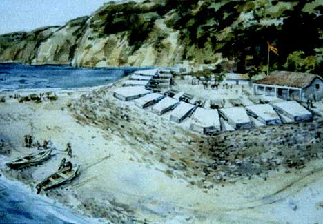
Figure 7.1 Fort Guijarros. 1990. Watercolor by Jay
Wegter. Hypothetical depiction of what the fort may have looked like based
upon archaeological and historical interpretation.
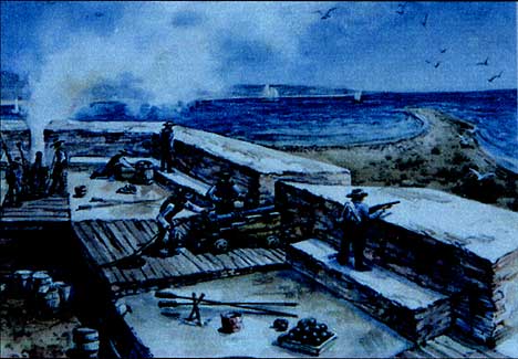
Figure 7.2 La Esplanada. 1990. Watercolor by Jay Wegter.
Hypothetical depiction of the soldiers at Fort Guijarros looking out at
the entrance to San Diego Bay.
The environmental setting has changed substantially since completion of
Fort Guijarros in 1796. Though the appearance and exact disposition of
the original Fort are unclear, archaeological investigation has revealed
important information about the nature of the Fort’s construction
(May 1982: 15-17). The foundation core rose approximately 6.5 feet above
the original beach level, and there was a cobble-covered fill slope which
the Spanish called a rampa along the outside of the wall. On the inside
was an earth and cobble-filled platform called the esplanade del cañones.
This was the area where the cannons rolled as they fired through the crenellations
in the wall. The upper walls, or superstructure, were made of cobble and
adobe and were about three feet above the esplanade del cañones.
Over 9,000 pesos were allocated in 1797 to complete the battery, magazine,
and barracks and to construct a flatboat to ward off imminent English
invasions. In 1801, a road was also constructed to connect the Fort with
the Presidio. Despite these efforts, Spanish authorities acknowledged
that San Diego’s fortifications were less than formidable. In the
event of an invasion, orders were for the guns to be spiked, the powder
and provisions burned, and the soldiers to flee. Though no invasion ensued,
the English threat helped rally efforts to complete the Fort. When Spain
announced its peace with England and Russia in 1802, fear of military
action subsided.
Ironically, it was not a British war ship but an American merchant brig
which brought about the now famous Battle of San Diego Bay in 1803. The
Lelia Byrd sailed in from Hamburg, loaded with European merchandise which
it intended to trade for otter pelts, despite Spanish trade prohibitions
in the Californias. The otter pelts had a great allure for merchants.
One pelt could sell for as much as 40 American dollars in China. Though
sale of these pelts was prohibited to foreigners by Spanish law, some
Spanish military authorities were known to participate in the lucrative
trade regardless. When William Shaler, Lelia Byrd’s master, and
Richard J. Clevland, the brig’s co-owner, heard that some 491 pelts
had been confiscated for illegal trade and were being held in a warehouse
at the Presidio de San Diego, they set sail for the port in an attempt
to obtain them. The Lelia Byrd sailed past Point Guijarros without challenge
and anchored about one mile inside the entrance and three miles from the
town and Presidio, within hailing distance of the beach.
Apparently, some of the authorities in San Diego were more scrupulous
than those in other California ports; three of Cleveland's men were detained
for trying to bribe a Spanish officer. Cleveland and a few other men managed
to rescue the three would-be smugglers at gun point. The captured Spanish
guards were placed on their ship as hostages. Shaler was promptly underway,
but made little headway due to the light morning wind. Approximately half
a mile north of the point, Shaler ordered six three-pound swivel guns
on the starboard side to be armed. The Lelia Byrd was under fire fully
three-quarters of an hour before arriving near enough to reach the Fort
with their small guns.
Swivel-guns were not used for long distance cannoneering; the ship held
its fire until within musket-range of the fort (approximately 100 yards,
or about where the Submarine Base swimming pool is now located); a large
target at that range. As they tried to make an escape past Fort Guijarros,
cannon fire was exchanged on both sides. The Fort sustained no real damage,
but the Lelia Byrd reportedly took two balls in the hull at water-level
and suffered damage to her rigging.
The brig did manage to make it out of the harbor, however, releasing its
hostages just out of range of the fort and sailing south to San Quintín
Bay for repairs. Despite the damages to the vessel, Cleveland, the co-owner
of the Lelia Byrd, described the Fort which had fired upon him as "a
sorry battery of eight-pounders… at present it does not merit the
least consideration as a fortification, but with a little expense might
be made capable of defending this fine harbor" (Bancroft 1886:103).
The importance of the battle, along with the 1851 map of Ballast Point
as prepared by the U.S. Coast Survey, offers insight as to the probable
geometry of the fort and the direction of cannon fire. Certain orientation
has been concluded given the firing headings and position of the excavated
contrafuera. In 1851, A.M. Harrison prepared The Tracing of the Plane
Table Sheet of San Diego, and the final map and survey were completed
by R.D. Cutts and George Davidson in 1853 (Figure 7.3). Harrison's tracing
shows a Battery Ruin in a curious expanded U-shaped form. This detail
was altered in Cutts and Davidson's map.
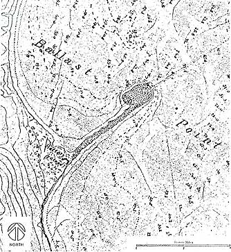
Figure 7.3 San Diego Bay, California. “Battery
(ruined)”; Enlarged detail of the tracing on the plan table sheet
of the San Diego Bay, California. Survey by A.M. Harrison. Source: U.S.
Coast Survey, 1851.
Indications of the Fort’s ruins are not found on the 1857 U.S. Coast
Survey. Based upon the events of the Battle of San Diego Bay and the apparent
geometry of the Fort, a probable plan was developed showing the cannon
firing headings (Figure 7.4). These headings protected three main critical
areas: (1) the entrance to the bay, (2) Ballast Point (in case of a possible
landing) and (3) the area around the point where the ships had to sail
due to the sounding depths as recorded on the 1783 La Pérouse Survey
Map No. 35.
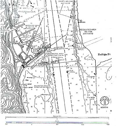
Figure 7.4 Fort Guijarros Probable Plan. Fort Guijarros Probable Plan shows cannon firing headings placed on NOAA San Diego Bay map with sounding depths. Source: NOAA and Architect Milford Wayne Donaldson, FAIA, Inc., dated 1996.
Anchorages are indicated around the point and closer to the mainland.
Due to the sandbars, it was not considered safe to sail up the center
of bay at this time. In her escape, the Lelia Byrd had to go down the
east coast of Point Loma and around Ballast Point before heading out to
open sea. The position of the Fort's guns, regardless of the skill of
the cannoneers, offered an excellent chance to do damage to any ship confined
within these narrow passages.
The positions of the gunports also appear to agree with this postulation.
The center four main guns point directly up Ballast Point to protect against
foreign hostile landings (Figures 7.5 and 7.6).
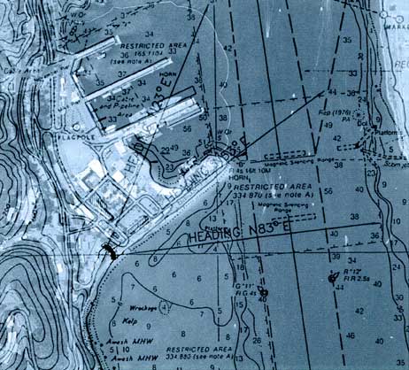
Figure 7.5 Fort Guijarros Site Plan with Cannon Firing Headings Composite Overlay. Site plan showing the fort with cannon firing headings superimposed over the present day topography. Source: Architect Milford Wayne Donaldson, FAIA, Inc., dated 1996 and Google Earth 2005 satellite imagery.
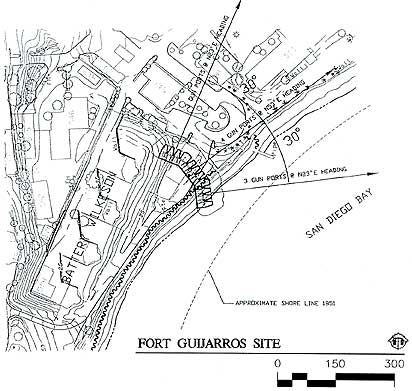
Figure 7.6 Fort Guijarros Site Plan. Site plan showing the fort with cannon firing headings. Source: Architect Milford Wayne Donaldson, FAIA, Inc., dated 1996.
The shoreline in the 1850s was considerably further out into the bay. A 1900s photograph of Battery Wilkeson looking towards Ballast Point confirms that even at this late date the shoreline was farther out in the bay (Figure 7.7).
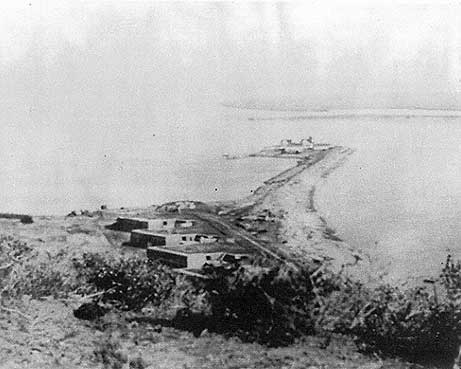
Figure 7.7 Battery Wilkeson. This view depicts Battery
Wilkeson and Fetterman overlooking the 1890 lighthouse and whaler’s
warehouses at the eastern tip of Ballast Point. The ruins of Fort Guijarros
would be to the right of the largest gun battery, Battery Wilkeson. Source:
Architect Milford Wayne Donaldson, FAIA, Inc.
Should this nomination be recorded as a National Register of Historic Places site, it would require that further detailed underwater archaeology be performed in the event of off-shore construction work in order to satisfy the Section 106 process. In the meantime, it would be exciting to perform additional archaeology under Building 539 (the Fire Station) to confirm the limits of the western wing of Fort Guijarros (Figures 7.8 and 7.9).
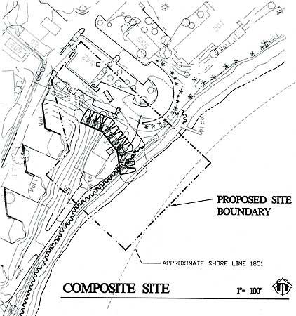
Figure 7.8 Fort Guijarros Composite Site. The composite site shows Fort Guijarros, Ballast Point Whaling Station, and the proposed site boundary. Source: Architect Milford Wayne Donaldson, FAIA, Inc., dated 1996.
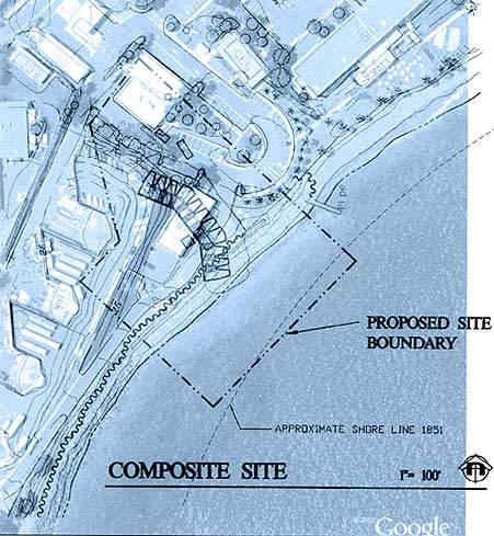
Figure 7.9 Fort Guijarros Composite Site Overlay. The
composite site overlay shows the proposed site boundary of Fort Guijarros
superimposed over the present-day topography. Source: Architect Milford
Wayne Donaldson, FAIA, Inc., dated 1996 and Google Earth 2005 satellite
imagery.
References Cited
Bancroft, Hubert Howe
1886 History of California. A.L. Bancroft & Company, San Francisco.
Corps of Engineers Map of the Site of Proposed Battery, Ballast Point,
Surveyed under the direction of Major Charles E. L. B. Davis, Corps of
Engineers,
Sept.-Oct. 1896. Fort Guijarros Map Collection, M:WILK-74 (1 of 3).
May, Ronald V.
1982 The Search for Fort Guijarros: An Archaeological Test of a Legendary
18th Century Spanish Fort in San Diego. Fort Guijarros 1(10):1-22. Tenth
Annual Cabrillo Historic Seminar.