
Home
Mission Statement
Editorial Policy
Submission Information
Volume One
Casual Papers
Fort Guijarros
Volume Two
To view pdf files you will
need Adobe Reader.
![]()
The Regional Consequences of Lake Cahuilla
Don Laylander
Many uncertainties surround the prehistoric chronology of Lake Cahuilla and the lifeways of the people who lived along its shores. Even more difficult questions concern the region-wide effects that may have resulted from the dramatic environmental transformations associated with the lake's rise and fall. Possible repercussions include the spread of technology, new distributions of languages and dialects, changes in subsistence strategies, population growth, increases in intra- and interregional trade, anomalies in settlement organization, and elevated levels of intercommunity violence. Although these repercussions are still primarily hypotheses to be tested, some of the regional patterns appear to be plausibly linked to the late prehistoric cycles of the lake.
The Characteristics of Lake Cahuilla as a Potential Causative Agent
Several features of the Lake Cahuilla phenomenon need to be considered in assessing its potential as a source for regional changes or cultural anomalies. These include the repetitive nature of the lake's changing levels, the time scales in which the changes occurred, the lake's geographical scale, and its effects on resources available for human use.
Cyclical Character
Until recently, it was commonly thought that the late prehistoric presence of Lake Cahuilla had been a single episode spanning at least five centuries, between about AD 1000 and 1500 (Rogers 1945). Subsequent evidence from radiocarbon dating and stratigraphic observations established that the lake's rise and fall were repeated events (Waters 1983; Wilke 1978). A minimum of three fillings and recessions occurred between about AD 1200 and 1700 (Figure 6.1; Laylander 1997a:64-68). This suggests a frequency of roughly one lacustrine cycle every 200 years, but that frequency may merely reflect the level of resolution that is presently obtainable from the radiocarbon dates. The possibility that additional cycles occurred during this period cannot be ruled out. There may have been earlier lacustrine episodes prior to AD 1200, although the question of their number and timing remains obscure (Love and Dahdul 2002; Waters 1980).
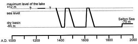
Figure 6.1 A tentative chronology for Lake Cahuilla
during the late prehistoric period.
Early models assumed that the rise and fall of the lake were unique events
and interpreted the connections between those events and various regional
archaeological and ethnographic phenomena accordingly. However, current
knowledge concerning the repetition of these events requires that such
interpretations be reconsidered. If the lake's first rise–whenever
it may have occurred–is proposed as having served as a stimulus
for various regional developments, a similar stimulus was likely exerted
several times subsequently. The lake's final recession in the late seventeenth
century should not be thought of as a unique event, except in hindsight
as a perspective following three dry centuries. Native responses attributed
to any one recession may have been repeated during several other periods.
Time Scale
The duration of the processes of change associated with Lake Cahuilla is another significant dimension. The lake’s appearance and disappearance were not sudden or brief environmental events, like earthquakes, hurricanes, or floods. At a minimum, the filling of the lake would probably have taken about twenty years to complete, and its recession would have taken three times that span (Figure 6.2; Laylander 1997a:45-54; cf. Waters 1980, 1983; D. Weide 1976; Wilke 1978).
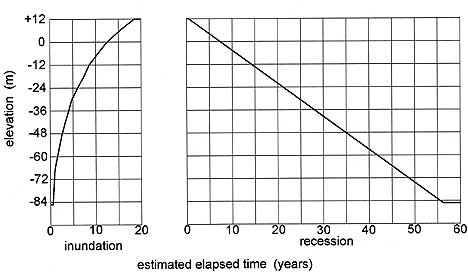
Figure 6.2 A scenario for the inundation and recession
of Lake Cahuilla, based on early twentieth century climate and hydrology
(Laylander 1997a:128).
These periods are too long in duration to have been bridged by the sorts
of emergency measures to manage subsistence that were a part of the normal
repertory for native cultures in western North America, such as using
stored foods or making temporary visits to relatives living outside the
affected region. On the other hand, the events were too abrupt and short-lived
to have been managed simply by the unconscious processes of gradual cultural
adaptation. In contrast to the situation with many important prehistoric
environmental shifts, such as rising sea levels or gradual climatic changes,
the people who lived through the various episodes of a rising or falling
lake were undoubtedly conscious of the changes that were happening around
them. It is also possible that oral traditions made them aware of the
pattern of previous lake cycles (see Laylander 2004a).
Within the main, decades-long episodes of inundation and recession, a
secondary sequence of changes occurred, so that the appearance and disappearance
of the lake did not represent simple events. Most of the lake’s
rise may have been too rapid for shoreline biological communities, in
particular marsh plants, to keep pace with its movements. The effects
of a rapidly rising lake on the populations of fish, shellfish, and water
birds remain uncertain. However, by the time the lake was nearly full,
its rate of rise must have slowed considerably, to 2 meters per year or
less compared to the rate of the lake's subsequent recession.
Once the lake was full, the shoreline may have stabilized for an indefinite
period. A degree of stability is suggested by the tufa deposits that formed
on rocks just below the lake's high water mark, by the well-developed
beach features in some areas, and by the numerous archaeological sites
that are associated with the maximum shoreline. How long the lake remained
at this level during each of its several fillings is unknown, although
a full lake was obviously present for much briefer periods than the 500-year
stand that was once suggested. Siltation of the lake’s relatively
low-gradient inlet channel that occurred once the lake had reached its
maximum level may have regularly diverted the Colorado River back to its
previous southward course fairly quickly. In any case, it seems likely
that the longer the stable maximum shoreline existed, the richer its associated
fauna and flora would have become.
The lake's recessions were slower than the rises, and they therefore had
a different character for the region’s prehistoric inhabitants.
Although complete desiccation could have been accomplished in about 60
years, archaeological evidence from fish remains attests that the receding
lake was refreshed by an inflow of water from the Colorado River on at
least one occasion (Schaefer 1986). The example of numerous small natural
floods of Colorado River water reaching the basin during the nineteenth
century suggests that such episodes might also have been common prehistorically
(Wilke 1978). Archaeological faunal remains of vegetation-adapted water
birds at recessional shoreline sites indicate that the floral community
was able to track the receding shoreline, which was therefore likely richer
in resources than the rising shoreline had been (Laylander 1997a:85-90).
On the negative side, recession was accompanied by gradually increasing
salinity levels, successively impoverishing and then eliminating the various
freshwater fauna and flora. However, there is evidence that fish and birds
continued to be exploitable at least as low as 55 meters below sea level,
or a minimum of about 40 years into the desiccation phase.
After the disappearance of the lake, climax biotic communities slowly
reestablished themselves on the dry lake bed. It has been suggested that
there was a separate stage in human adaptations to the basin after the
lake was gone but before mature mesquite groves established themselves
(Wilke 1978:13-14; cf. Schaefer et al. 1987:22). Contrary to this is the
fact that the exposure of the lake bed was a gradual process lasting decades,
and desert plant communities must have established themselves at successively
lower elevations above the retreating shoreline, even while the lake resources
were still available.
Geographical Scale
The size of Lake Cahuilla is also a significant dimension to be considered in assessing aboriginal responses to its cycles. About 180 km long and up to 50 km wide, the full lake had a surface area of about 5,500 km2 and a perimeter of more than 400 km of shoreline (Figure 6.3). The lower Colorado River delta included an additional 3,500 km2 of lands whose condition was directly linked with the fate of the lake.
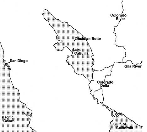
Figure 6.3 Lake Cahuilla, the lower Colorado River,
the Colorado delta, and the surrounding region.
The lake's large size would have constrained the range of aboriginal options
for responding to its presence. If the lake and the delta had been substantially
smaller than they were, they might have been monopolized by a single community,
or at least by a single ethnolinguistic group. Under those circumstances,
the inhabitants of the lake basin and the delta might have minimized their
responses to the resource shifts that arose from the lake cycles. But
Lake Cahuilla’s great size almost inevitably made it an “international”
phenomenon. Different groups could have entered the basin independently
from several different directions. Diverse responses to the loss of the
lake's resources would likely have been produced by the diversity of the
hinterlands that lay in different directions outside the basin, as well
as by the competition among different groups.
As documented ethnographically, the Lake Cahuilla basin and Colorado River
delta were split among at least three major ethnolinguistic groups: the
Cahuilla in the northern portion of the basin, the Kumeyaay in the southern
basin, and the Cocopa in the delta (Figure 6.4).
Ethnic distributions during earlier periods when the lake was present
are uncertain, but there are indications that at least three groups can
also be distinguished archaeologically within the basin. On the eastern
shoreline, eastern types of Lower Colorado Buffware ceramics suggest the
presence of River Yumans, similar to the ethnographically known Mohave,
Halchidhoma, and Quechan. On the northern and northwestern shoreline,
it is likely that Takic speakers, specifically the Cahuilla, were present,
as indicated by peculiarities in ceramics, arrow points, and shell beads.
On the southern and southwestern shoreline, Delta-California Yumans such
as the Kumeyaay and Cocopa were the most likely occupants. In sum, there
is no reason to posit the existence of a single Lake Cahuilla People or
expect that there would have been a unitary response to the loss of the
lake.
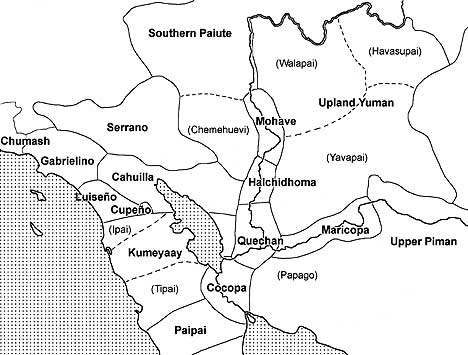
Figure 6.4 The ethnographic distribution of linguistic
groups in the region around Lake Cahuilla.
Effects on Resources
The most critical issue in evaluating possible regional repercussions
of Lake Cahuilla's changing levels concerns the lake's effects on the
availability of subsistence resources. The matter has sometimes been framed
as a debate between the Weide and Wilke models for settlement and adaptation
to the lake. According to the Weide Model, because of the instability
of the lake, lacustrine resources were relatively unreliable and sporadically
distributed, settlement on the lakeshore was only seasonal, and reliance
on the lake was no more than a secondary element within regional adaptive
strategies (Schaefer 1994; M. Weide 1976). On the other hand, according
to the Wilke Model, lake resources were extensively used, lakeshore settlement
was nearly year-round, and therefore, the loss of resources carried great
regional consequences (Wilke 1978).
Lake Cahuilla's appearance within its basin must have been a strongly
positive development from the standpoint of the resources provided. It
is true that the areas flooded by the lake were presumably used by native
peoples during dry periods, but such use was probably of minor importance,
as was the case for the portions of the Imperial and Coachella valleys
lying below the maximum shoreline in the subsistence strategies of later,
ethnographically known groups. Mesquite was a significant resource, and
the rise of the lake may have reduced the total regional mesquite crop.
Salt may have been harvested from the lake’s dry playa, although
it was of lesser importance. The obsidian deposits at Obsidian Butte became
unavailable once the lake had risen above the level of 40 meters below
sea level. When obsidian from this source was available, it was collected,
used locally, and traded or carried westward to coastal southern California,
but it appears unlikely that it had any major economic importance.
New resources made available by the lake would have more than offset the
losses mentioned above. Archaeological evidence suggests the harvesting
and consumption of fish, shellfish, waterfowl, and marsh plants at lakeshore
sites (e.g., Laylander 1997a:86-90; Sutton and Wilke 1988; Wilke 1978).
Although the economic value of these resources is not easy to quantify,
it likely far exceeded the local losses in mesquite and other dry-phase
resources. The availability of potable water was another critical resource
for human survival in the hot, arid Colorado Desert. The water of the
lake and the high water table near its shores probably supported richer
populations of non-lacustrine plants and animals than would otherwise
have been present. Those augmented populations, in turn, became available
for human exploitation.
If the rise of the lake substantially enhanced the resources of the Coachella
and Imperial valleys, a different situation existed farther south in the
Colorado River's delta. As documented ethnohistorically and ethnographically,
the delta was a rich environment for human settlement. Wild rice, quelite,
fish, and water birds were major natural food resources, along with numerous
minor ones. The delta also allowed for floodwater agriculture (Castetter
and Bell 1951; Kelly 1977). However, when the river's flow diverted north
into the Lake Cahuilla Basin, the diversion was substantially total, the
making the delta unattractive to humans for a period lasting nearly two
decades. After the basin filled, the river would have once again sent
part of its water, perhaps amounting to about half of its total flow,
into the delta by way of the lake’s outlet. This would have made
the delta inhabitable, although perhaps with a proportionately lower share
of resources than under non-lacustrine conditions. When the river diverted
its full flow directly to the delta once again, that environment was gradually
enriched while the isolated lake to the north receded. Resource conditions
in the delta and in the Lake Cahuilla basin were thus to some extent complementary,
perhaps triggering a synchronization of prehistoric human responses.
Regional Ethnographic and Archaeological Patterns
The Spread of Technology
One of the earliest archaeological suggestions for a regional effect from
the inundation and recession of Lake Cahuilla was the spread of a ceramics
industry westward, first from the lower Colorado River into the Lake Cahuilla
basin and then from the basin to the mountains and coast of southern California
and northern Baja California. Malcolm J. Rogers thought that the lake
rose around AD 1000, at which time Yuman-speaking people had carried pottery-making
from the lower Colorado River into the Lake Cahuilla basin (1939, 1945).
When the lake had receded around AD 1500, according to Rogers, ceramics
passed to the Peninsular Range and the Pacific coast.
Rogers' model for the spread of ceramics is no longer compelling, as it
is now believed that there were several shorter lake stands rather than
a single long one, and those stands took place both prior to AD 1000 and
after AD 1500. Pottery was likely manufactured and used earlier than Rogers
thought, both within the Lake Cahuilla basin and in the Peninsular Range
(Griset 1996; Waters 1982). Certain current hypotheses assert that ceramic
technology in the western areas developed to a large extent independently,
rather than being copied from the east (Griset 1996).
A link between the spread of ceramic technology and ethnic migration also
seems less convincing now than it did when Rogers wrote. Archaeological,
early historic, and ethnographic evidence makes it clear that west coast
groups were in close contact with the peoples who lived beside the lower
Colorado River. The westerners would therefore have had access to the
technological ideas required for pottery production. What was critical
for the spread of ceramic technology was not access to information about
how to make pottery, but rather the proper economic incentives and circumstances,
such as a fair degree of sedentism that would have made pottery an attractive
alternative to other types of containers. These factors can only be indirectly
linked to the cycles of Lake Cahuilla.
The Distribution of Languages
Traces left by the cyclical appearance and disappearance of Lake Cahuilla
may exist in the region’s map of aboriginal languages. In principle,
a region that had experienced long-term territorial stability would be
expected to contain a mosaic of optimally sized linguistic communities
that were only remotely related to each other (cf. Dixon 1997). In contrast,
regions that had experienced very recent ethnic expansions or migrations
by some groups at the expense of others might be recognized by the presence
of single-language communities with dialect-level variation spread across
areas that would have been too extensive for linguistic unity to have
been maintained over the long term. If such expansions or migrations had
occurred less recently, the resulting pattern in linguistic geography
might be an array of sister-languages belonging to an easily recognized
linguistic family. If Lake Cahuilla's resources played an important role
in supporting elevated population levels within its basin, then the loss
of those resources when the lake dried up may have stimulated migrations
at the expense of neighboring groups. With time, migrant groups may have
become linguistically differentiated from their kin who either had not
migrated or had moved in other directions. There are several linguistic
patterns in the region that may reflect repercussions from the lake's
late prehistoric cycles.
Speakers of Yuman languages occupied areas to the south and east of the
Lake Cahuilla basin. Yuman is one of at least 13 linguistic families that
are mostly scattered around the periphery of California and that seem
to have been distantly related to each other within the Hokan phylum.
Yuman was by far the most extensive of the Hokan families; it had the
largest number of member-languages, and it probably also had the largest
number of pre-contact speakers. This distinctiveness in territorial and
demographic size and in diversity is further enhanced if Yuman’s
closely related sister family, Cochimí, which adjoined Yuman to
the south in central Baja California, is taken into consideration (Mixco
1978). The geographical extent of the Yuman family suggests that a substantial
territorial expansion had taken place at some time during the second half
of the Holocene.
The available methods for dating the separations between languages are
imprecise at best. Glottochronology offers an approach to linguistic dating
that is comparatively objective, although its validity has been seriously
challenged by many linguists. For what it may be worth, a glottochronological
estimate has put the separation of Yuman into its four major branches–River,
Delta-California, Pai, and Kiliwa–at about 1,700-2,500 years ago
(Laylander 1997b:66; cf. Ochoa 1982; Robles 1965). This suggests that
the formation of these branches predated the late prehistoric period,
and was prior to at least the three most recent stands of Lake Cahuilla.
However, the division of the three northern Yuman branches (Delta-California,
River, and Pai) into their constituent languages brings this discussion
closer to the period when something is more securely known about the status
of Lake Cahuilla.
Delta-California Yuman includes a minimum of two languages, Cocopa and
Diegueño, and a maximum of eight languages, if a separate status
is accorded to Cocopa, Kahwan, Halyikwamai, Ipai, Kumeyaay, Tipai, Huerteño,
and Kwatl. Glottochronology suggests that there was a separation of 1,200
years or less within this branch of the Yuman family. The ethnographically
recorded location of the Delta-California Yumans both on the southwestern
and southern margins of the former lake and to the west of the lake basin
would fit with the hypothesis that outward expansion toward the west and
south may have been triggered by one or more of the lake's episodes of
desiccation.
Accounts of the Colorado River’s delta by early Spanish visitors
identified the presence there of several groups, including those generally
known subsequently as the Cocopa, Kahwan, and Halyikwamai. In the early
nineteenth century, the Kahwan and Halyikwamai moved out of the delta
to the middle Gila River, where they joined with River Yumans, the Maricopa.
Linguistic evidence concerning the Kahwan and Halyikwamai is very limited,
but what little evidence is available suggests that their speech may have
been essentially identical to that of the Cocopa (Kroeber 1943:21-22).
The three delta groups may have been primarily sociopolitical rather than
cultural-linguistic groupings, but it is noteworthy that their recognition
as distinct entities persisted through more than three centuries of the
protohistoric period. This suggests that the Yumans living in the delta
were in an early stage of cultural fission into three ethnolinguistic
units, reflecting a process of differentiation that had begun less than
1,000 years ago, perhaps only a very few centuries prior to contact. Such
a fission could be connected to some territorial expansion occurring as
part of one of the late prehistoric cycles of Lake Cahuilla.
Scholars disagree as to the amount of linguistic differentiation present
within Diegueño, or Kumeyaay. Some interpretations suggest that
only a single language is represented, while lexicostatistical evidence
seems to hint at as many as five separate but closely related languages.
Currently, the most widely accepted interpretation is that there are three
distinct languages: Ipai in the north, Kumeyaay in the center and east,
and Tipai in the south (Goddard 1996; Kendall 1983; Langdon 1990). This
would suggest that linguistic fission was triggered within this group,
perhaps about 1,200-1,000 years ago, with the possibility of some more
recent, dialect-level breaks as well.
The distribution of the River Yuman languages offers fewer hints of repercussions
from Lake Cahuilla. The Halchidhoma were recorded in the Colorado delta
in 1605, prior to the lake’s final stand, but they had relocated
themselves farther north, near Blythe, when they were next heard from
in the eighteenth century. They then moved to the middle Gila to join
the Maricopa in the early nineteenth century (e.g., Laylander 2004b).
One scenario suggests that the Maricopa may have ventured from the lower
Colorado River to the Middle Gila in the thirteenth century, a move that
might have been associated with a lake cycle (Harwell and Kelly 1983:73;
Spier 1933:11-12).
At first sight, the Pai branch of Yuman seems remote from Lake Cahuilla.
There are two Pai languages: Paipai in northern Baja California, and Upland
Yuman in northwestern Arizona. The latter is commonly divided into the
sociocultural groupings of the Yavapai, Walapai, and Havasupai. Neither
of the Pai languages was spoken within or adjacent to the Lake Cahuilla
basin. However, it is striking that the areas in which the two languages
were spoken were not contiguous, as were the territories of sister-languages
within the other Yuman branches, but instead were separated by a gap of
about 200 km. The midpoint between the territories of the Pai languages
falls within the Colorado River delta. There is no accepted estimate as
to how long ago Paipai and Upland Yuman became separated from each other,
but the relationship between the languages is a close one. Perhaps 1,200-1,000
years would once again be a reasonable guess, although some scholars would
see the relationship as much closer (cf. Winter 1967). The direction of
migration is uncertain. Some modern oral traditions seem to point toward
a movement of the ancestral Paipai from western Arizona to Baja California
(e.g., Meigs 1977; Mixco 1977; Wilken 1993; Winter 1967), while linguistic
indications seem to favor movement in the reverse direction (Joël
1998; Laylander 1997b). Migration of both groups from a third location
is also a possibility. In any case, some dramatic event during the late
prehistoric period seems necessary to account for the geographic separation
of the two languages. A cycle of Lake Cahuilla is one candidate.
The geographical extent of the area occupied by the Upland Yuman language
and the fission of its speakers into three culturally distinct and sometimes
hostile ethnic groups (the Yavapai, Walapai, and Havasupai) also calls
for comment. The territory occupied by Upland Yuman speakers amounted
to about 100,000 km2, perhaps more land than could be maintained indefinitely
as a single language unit. The sociopolitical fission into Yavapai, Walapai,
and Havasupai is a likely result of this proposed instability. If that
inference is correct, the expansion of the Upland Yumans through much
of western Arizona must have been a relatively recent phenomenon, begun
less than 1,000 years ago. Ethnic displacements from the Lake Cahuilla
basin or from the Colorado delta are possible as either direct or indirect
catalysts for the Upland Yuman expansion.
The distribution of the Takic (Uto-Aztecan) languages offers fewer hints
at possible effects from the late prehistoric lake. A noted feature of
aboriginal southern California’s linguistic geography was the "Shoshonean
Wedge." Speakers of Takic languages occupied the coastline between
Malibu and Carlsbad, separating two Hokan-speaking families, the Yumans
to the south and the Chumash to the northwest. However, the relationship
between Yuman and Chumash languages is at best an extremely remote one,
perhaps dating back to the early Holocene. Additionally, a study of borrowed
words within the basic vocabularies of the coastal Takic languages, Gabrielino
and Luiseño, suggests that those groups displaced or absorbed the
speakers of a previous coastal language or languages that were distinct
from both Yuman and Chumash (Bright 1976; Laylander 1985). The major linguistic
fissions within Takic, and therefore the territorial expansions that probably
produced them, all appear to predate the late prehistoric period. Glottochronology
suggests that (1) Takic became differentiated from the other northern
Uto-Aztecan branches around 3,000-4,000 years ago; (2) Takic divided into
Cupan and Serrano-Gabrielino around 2,500 years ago; and (3) Cupan split
into Luiseño, Cupeño, and Cahuilla more than 2,000 years
ago. The expansion of Takic speakers to the southern California coast,
forming the Shoshonean Wedge, would most plausibly be associated with
either the first or the second of those linguistic fissions.
One feature of Takic linguistic geography perhaps related to late prehistoric
Lake Cahuilla is the dialect-level distinction between Mountain, Pass,
and Desert Cahuilla (Seiler 1977:6-7). The time depth of this division
is unclear, although estimated at 1,000 years ago, assuming that it reflected
linguistic instability that was gradually leading toward a language-level
split. It is possible that the cultural differentiation of these three
subgroups reflects an episode of ethnic expansion, either eastward from
the Peninsular Range to the shore of Lake Cahuilla, or westward into the
mountains, away from the drying lake basin. However, the dialects might
merely reflect stable variability within the language, and that their
centrifugal tendencies from local change were completely balanced by centripetal
tendencies to maintain mutual intelligibility throughout Cahuilla territory.
Demography
Many of the suggested regional repercussions from Lake Cahuilla are related
to a demographic disequilibrium associated with abrupt changes in the
basin's carrying capacity. Groups that were displaced from the basin or
from the Colorado delta may have raised the population densities within
surrounding areas, either temporarily or permanently.
The size of the region's late prehistoric and protohistoric population
is difficult to determine. It is not uncommon for ethnographic estimates
of pre-contact populations to vary by a factor of two, and sometimes by
as much as a factor of five (e.g., Heizer 1978; Hicks 1963; Kroeber 1925;
Shipek 1986; White 1963). Estimation of regional populations by means
of archaeological evidence has not been seriously attempted, and such
a project would face daunting difficulties. If the population of the surrounding
region is known only roughly, the situation within the basin when Lake
Cahuilla was present is also uncertain. Homer Aschmann gave a range for
population estimates between 20,000 and 100,000 for the basin (1959:45).
The latter figure certainly seems too high, and even the former may well
be excessive, but there is no good basis at present for a sounder estimate.
Aschmann postulated a "great migration" of people faced with
starvation, resulting in "an extraordinarily vicious war pattern"
on the Colorado River but "some sort of peaceful accommodation of
an enormous influx of former desert dwellers" by coastal groups to
the west (1959:45). James F. O'Connell (1971) and Wilke (1974) similarly
suggested that significant population increases had occurred in the surrounding
areas as a result of migrations out of the former lake's basin.
It is reasonable to ask whether the relative density of the late prehistoric
and protohistoric population in the region was greater than might have
been expected in the absence of the Lake Cahuilla phenomenon. According
to estimates by Frederic N. Hicks, the aboriginal population densities
for the groups living along the Colorado River ranged between 2.0 and
3.4 people per km2, and the densities in the deserts, mountains, and coastal
plains to the west of the river ranged from 0.15 to 1.0 people per km2
(1963). The dense settlement along the river is plausibly associated with
the practice of floodplain agriculture there, but the question remains
open: was the population density so high because agriculture was practiced,
or was agriculture practiced because the population density was high?
The population sizes among the western groups are also notably large if
viewed within a worldwide perspective (Kelly 1995:222-226). However, that
was true for native California in general, in a zone extending well beyond
the range of any likely effects from the lake.
Subsistence Strategies
Anomalies in the use of non-lacustrine subsistence resources are another
set of possible symptoms for regional changes associated with Lake Cahuilla.
Among the processes stimulated by environmental instability may have been
a more intensive exploitation of some previously used resources, the addition
of new and presumably lower-ranked resources, maintenance of a diversified
resource strategy as a hedge against that instability, and relaxation
of cultural mechanisms promoting sustainability in resource exploitation.
The phases of the lake that involved the wholesale disappearance of lacustrine
or deltaic plants and animals may have seriously affected the total quantities
of the preferred subsistence resources that were available within the
region. If so, perhaps that compensation would have been sought in the
adoption of less attractive, higher-cost subsistence strategies. Such
subsistence changes might also have occurred as the result of technological
advances or population increases that were unrelated to environmental
change. The detailed analyses that might make it possible to distinguish
among these various causes behind subsistence change have generally not
been performed. However, it is worthwhile to examine what was distinctive
about late prehistoric subsistence practices in the region and to consider
Lake Cahuilla as at least one potential explanation.
Agriculture was the most striking late prehistoric innovation in subsistence.
The Yumans on the Colorado River were growing crops when the Spanish encountered
them in 1540. It is likely that local agriculture predated that event
by several centuries, although the timing of its introduction is yet unknown.
Among the peoples of the river and the delta, ethnographic records show
that agricultural crops constituted an important, but not a dominant,
food source. Estimates of the dietary contribution from agriculture range
between a high of 40-50% among the Mohave to about 30% for the Cocopa
(Castetter and Bell 1951). Some Kumeyaay (Kamia) lived with the Quechan
on the Colorado River in early historic times, where they presumably practiced
agriculture. The eastern Kumeyaay also planted crops in the parts of the
Imperial Valley that were watered by natural overflow from the Colorado
River (Gifford 1931). Whether the Cahuilla of the Coachella Valley practiced
agriculture prior to the advent of European influences is disputed (Bean
and Lawton 1973; Lawton 1974; Schaefer and Huckleberry 1995; Wilke et
al. 1977). It has been suggested that the prehistoric Yuman and Takic
groups in the Peninsular Range and on the Pacific coast may have engaged
in agriculture to a significant extent (Bean and Lawton 1973: Forbes 1963;
Shipek 1986, 1993), but this view has also been challenged (e.g., Laylander
1995).
One explanation for the advent of agriculture late within the prehistoric
period is that the domesticated crop plants (primarily maize, tepary beans,
and squashes or pumpkins), as well as the techniques for their cultivation,
only became available after they spread from their centers of development
elsewhere in parts of North America. An alternative view would be that
the cultigens and techniques were potentially available at an earlier
time, but that the added labor costs involved in their exploitation were
only bearable after the regional population had risen to a level that
could no longer be supported by less costly methods of subsistence. Such
population-related subsistence stress might have been related to any of
several causes: a gradual growth of population acting as an essentially
independent variable through time; a spurt of population growth induced
by social factors, such as interethnic military competition; or episodic
population displacement and subsistence stress relating to environmental
perturbations, such as those arising from the cycles of Lake Cahuilla.
Future studies may be able to date the introduction of agriculture more
accurately, establish its pre-contact geographical range, evaluate its
relative costs and benefits under aboriginal conditions, and clarify the
possible role of Lake Cahuilla in its adoption.
A striking feature of late prehistoric subsistence in the Peninsular Range
and the coastal valleys west of the Lake Cahuilla basin was the prime
importance attributed to acorn harvesting. Archaeological site frequencies
suggest that the occupation of these parts of the region became much more
intensive during the late period than it had been during earlier times
(e.g., Christenson 1990). There was a significant later proliferation
of bedrock milling features primarily associated with acorn processing.
Ethnographic evidence indicates that acorns were the single most important
subsistence resource for the western Kumeyaay, Luiseño, Cupeño,
and western Cahuilla. It is conceivable, but not very likely, that the
late florescence of acorn use was induced by a technological innovation:
the discovery of how to leach acorns to make them edible. More probably,
late peoples had known of the potential but turned to the region's abundant
acorns only when other resources that were less costly to process were
no longer sufficient to feed a growing population. A similar late prehistoric
rise in acorn use, probably associated with rising population density,
is reported throughout much of California, far beyond the zone that can
plausibly be connected with Lake Cahuilla (e.g., Basgall 1987). Late prehistoric
demographic growth in the southwestern part of California may also have
been unrelated to events in the Lake Cahuilla basin, but it is possible
that the displacements associated with the lake played a role in inducing
subsistence stress and in stimulating the local development of an acorn-based
economy.
Agave was another resource of key importance, particularly among the people
who lived along the eastern margins of the Peninsular Range, including
the Cahuilla, eastern Kumeyaay, and Paipai. For some of these groups,
ethnographic evidence indicates that agave was the primary subsistence
resource, taking over the role that was being played by acorns farther
west. Agave hearts or stalks were processed by roasting in large, usually
rock-lined pits; the archaeological remains of thousands of these features
dot the eastern margins of the Peninsular Range. Some limited radiocarbon
sampling of roasting pits in southeastern San Diego County suggests that
the features primarily postdate AD 1350, and M. Steven Shackley (1983,
1984) posited a correlation between the florescence of pit roasting and
the recession of Lake Cahuilla. As in the case of acorns, an upsurge of
agave processing may have been part of a pattern of regional subsistence
intensification linked to population growth. The possibility that it was
specifically related to groups that had been displaced from the western
shores of Lake Cahuilla merits further consideration.
Pine nuts were a resource with a somewhat more limited distribution, but
they played an important role in some parts of the Peninsular Range. The
chronology of local pinyon exploitation is unknown. Given the evident
upsurge of settlement in the mountains during the late prehistoric period
(e.g., Graham 1981; True 1970), it would not be unreasonable to suggest
that nuts were part of an intensified regional subsistence strategy, although
the evidence to confirm or refute this suggestion is presently lacking.
In addition to adopting the use of new subsistence resources or intensifying
the use of old ones, the region's cultures may have responded to environmental
instability through changes in their general approaches to resource use.
One such response might have been toward diversification, or generalization.
Perhaps particular resources were cyclically made available but were then
lost because of the changes occurring in the lake basin and the delta.
If so, it may have been important for the prehistoric inhabitants of the
region to maintain their familiarity with the procurement and use of a
wider range of potential substitute resources than would have been necessary
under more stable environmental conditions. Several ethnographers argued
that the peoples living along the lower Colorado River made use of that
region's subsistence potential in a manner that was less than optimal
(e.g., Castetter and Bell 1951:68-72; Kelly 1977:23). Some early historic
observers attributed this to "laziness" (Bolton 1930:4:108;
Hammond and Rey 1953:1017). Such a failure to optimize, which was being
criticized from a synchronic perspective, may have made good sense diachronically,
as a defense against the effects of recurrent environmental changes.
Even more speculatively, another response to dramatic environmental change
may have been for people in and around the Lake Cahuilla basin to relax
prevailing cultural mechanisms for sustainability in the ways they exploited
particular resources. Sustainability in subsistence practices has been
attributed to many hunter-gatherer cultures, although this may possibly
be a modern environmentalist twist on the “noble savage” myth.
Substantial evidence for the existence of any cultural mechanisms to enforce
such a pattern is often lacking. Assuming that mechanisms protecting sustainability
and preventing overexploitation of resources did commonly exist, they
might have been suppressed in areas such as the Lake Cahuilla basin and
the Colorado River delta. Experience in those areas would have indicated
that resources that were not fully used would be lost to the recurrent
environmental disasters.
Trade
Intra- and interregional exchange systems offered a potential mechanism
for buffering the effects of environmental instability in the Lake Cahuilla
basin and the Colorado delta. Exported goods may have been directly traded
for subsistence resources in periods of stress. The social links that
were created through exchange may also have served to create places of
refuge for displaced persons, or allies for those involved in conflict.
Archaeological, historical, and ethnographic evidence attests to the existence
of trade networks linking the Pacific coast with the Colorado River valley
and parts of the American Southwest still farther east, as well as to
north-south connections between the Gulf of California and the Great Basin
(e.g., Bennyhoff and Hughes 1987; Davis 1961). The most archaeologically
visible elements of trade, such as pottery and shell ornaments, were items
that do not directly reflect subsistence. This may indicate that the establishment
of social ties between individuals and communities was more important
than strictly economic complementarity, but it is also possible that the
surviving material record is misleading in this respect.
Early historic accounts attest to visits made by Mohave and Halchidhoma
travelers to the southern California coast (Forbes 1965:61-62). Such trips
had to cover distances of more than 400 km, crossing several ethnic boundaries.
Direct trade on this geographical scale was unusual in aboriginal California,
and its existence here may point to a heightened emphasis on exchange
within the southern part of the state.
The westward movement of obsidian from the Obsidian Butte source on the
bed of Lake Cahuilla is another suggestive pattern. The movement of this
material, whether in trade or through direct procurement, was greatly
enhanced during the latest part of the late prehistoric period. Evidence
for this comes from the increased frequency of obsidian specimens in late
sites in montane and coastal southern California and from the regional
distribution of hydration values. The upsurge in obsidian use may have
been part of a general pattern of enhanced trade, or it may have been
a specific mechanism for extracting economic value from labor within the
dry Lake Cahuilla basin. Alternatively, it may merely indicate that the
obsidian source area had not usually been accessible during earlier periods,
because it was submerged whenever the lake waters stood 40 m below sea
level.
Settlement and Social Organization
Another symptom of environmental instability may be the social organization
of communities in the region surrounding the Lake Cahuilla basin. All
of the ethnographically documented peoples of the region possessed patrilineal
descent groups. In the case of the Takic-speaking Cahuilla, Serrano, and
Luiseño, these patriclans were localized in particular communities
(Heizer 1978; Strong 1929). It may be hypothesized that this Takic model
for social organization was the region's basic pattern, and that deviations
from it arose as a result of specific causes, which may have included
an influx of people displaced by environmental change.
Among the Yumans living on the Colorado River and in its delta, the patriclans
were rather weak spatially intermixed units. Settlement was usually dispersed
into scattered homesteads and hamlets, rather than being nucleated in
villages. Hicks (1974) plausibly attributed this settlement pattern to
the exigencies of floodplain agriculture, which required that families
live close to their fields and change their residences from time to time
as the flooding river shifted its course. It is also possible that population
shifts into and out from the river valley as a result of the lake cycles
contributed to this breakdown in the importance and localization of patriclans.
The social and settlement organization of the western Yumans, including
the Kumeyaay and Paipai, are less clearly defined (Laylander 1991). Most
early twentieth century ethnographers reported essentially clan-based
settlements similar to those of the Takic groups, although a few later
analysts have suggested an institutionalized dispersion of the clans into
multi-clan settlements (e.g., Shipek 1982). Most of the authoritative
accounts also indicated that whereas there was a strong tendency toward
clan localization as a cultural ideal, in practice the settlements commonly
contained representatives from more than one clan. Furthermore, a particular
clan was likely to be represented at more than one settlement. If this
system is interpreted as a partial breakdown of an underlying Takic settlement
model, then recent disruptions as a result of the influx of outside population
from the basin or delta could help to explain the deviations.
Warfare and Political Organization
Another symptom of social instability potentially induced or aggravated
by the environmental instability associated with Lake Cahuilla was the
exceptional importance and scale of intercommunity violence on the lower
Colorado and Gila rivers. If the appearance and disappearance of Lake
Cahuilla caused significant dislocations for people within the region,
one outcome of those dislocations may have been conflicts over territories
lying outside of the lake basin. Even if conflicts were not rationalized
by the participants as territorial struggles, they might have arisen from
and dealt with the interethnic stresses resulting from serious losses
in regional resources.
The contrast between patterns of warfare in most of California and those
followed along the lower Colorado River is striking. Native Californian
cultures have sometimes been characterized as essentially pacific, although
this is valid only in a relative sense, or if the category of warfare
is limited to specific types of intercommunity violence that are characterized
by elevated numbers of combatants and casualties, tactical organization,
or persistence. For example, Joseph G. Jorgensen (1980:240) defined warfare,
as distinct from raiding, as "a political act engaged in by two groups,
each possessing definite leadership, military tactics, and the expectation
that a series of battles could be endured." In his survey of ethnographic
information on aboriginal cultures throughout western North America, Jorgensen
identified only two areas where warfare in this restricted sense was practiced:
among the Tsimshian of coastal British Columbia, and among the River Yumans.
Colorado River warfare appears to have commonly involved unusually large
political units—whole ethnolinguistic groups, or collaborative ethnolinguistic
groups with longstanding alliances. Of note were a system of two adversarial
alliances centered on the Mohave and Quechan on one side and on the other
their enemies, the Cocopa and Maricopa. According to Jorgensen's survey,
district-level political organization, with units encompassing multiple
villages, was relatively rare in western North America. However, this
organization was reported for the Nisenan, Salinan, Chumash, and River
Yumans. In the case of the River Yumans, the functions and authority of
district-level (tribal) leaders were almost exclusively military, rather
than economic, judicial, or ceremonial.
Warfare was also deeply imprinted in the ceremonial behavior of the Colorado
River groups. In the case of the Mohave, for example, this was evidenced
in the formal, named social roles associated with warfare, including braves
(clubbers), spies, scalpers, scalp custodians, and female scalp dancers;
elaborate ceremonial behavior, including pre-combat conferences, anticipatory
funeral singing, observation of omens, and post-combat victory ceremonies
(notably the scalp dance); a special place in the afterlife reserved for
braves or men killed in battle; and the exceptional prominence accorded
to accounts of warfare in traditional narratives (Fathauer 1954; Kroeber
1948, 1951, 1972).
A variety of different interpretations have been offered as to why the
Colorado River cultures assigned an unusually large role to military matters.
Some analysts see the pattern as primarily protohistoric, attributable
to European disruptions and the incentives of raiding for slaves and horses
(e.g., Dobyns et al. 1957). However, the pervasiveness of militarism in
the Colorado River cultures seems to suggest a longer-established phenomenon.
Early historic accounts strongly suggest that chronic warfare was already
present at the period of initial contact prior to any substantial European
influences, although effects emanating from the frontier of European control
may later have reinforced this tendency.
Some of the explanations offered to account for Yuman militarism are essentially
ideological. For example, George H. Fathauer (1954:114) argued that economic
or material reasons for Mohave warfare were unimportant, at least once
the Mohave were established in their traditional homeland, and that their
observed bellicosity was essentially “an expression of their nationalistic
religious philosophy.” Viewed from an essentially emic or synchronic
perspective, Fathauer's argument has considerable support. Yuman warfare
was often conducted far from the aggressors' own territories, typically
entailed little or no attempt to seize crops or possessions or to occupy
conquered land, and participants' accounts of their own motivations emphasized
factors such as the pursuit of prestige or revenge rather than material
gain. On the other hand, if there was indeed an ethos among these groups
that accounted for the persistence of chronic warfare without immediate
material objectives, the question remains as to how this unusual ethos
originated. Is it necessary to dismiss it simply as an aberration arising
from the hazards of random cultural mutation? Or were there unusual material
circumstances that motivated the creation of such an ethos?
Economic explanations for Colorado River warfare include those offered
by Chris White (1974), Albert H. Schroeder (1981), and Connie L. Stone
(1981). White argued that warfare and the system of ethnic alliances associated
with it served to alleviate periodic subsistence stress. Stone similarly
suggested that River Yuman warfare was a response to frequent food shortages.
Food theft was a definite feature of some raiding, and disputes over mesquite
gathering rights and prime agricultural lands may have functioned as a
casus belli. Schroeder proposed that trading was a key factor in Colorado
River warfare, arising from a need to protect trade lanes and from competition
between rival trading centers.
If Colorado River warfare was generally not formulated emically as a struggle
for control over territories or resources, its most prominent consequences,
viewed etically, seem to have been territorial. First the Maricopa and
Kavelcadom, and subsequently the Halchidhoma, Kahwan, and Halyikwamai,
left the lower Colorado River and migrated to the middle Gila River, where
they became culturally consolidated as Maricopa (Spier 1933). Early historic
accounts also mention the presence of other unnamed or presently unidentifiable
groups living on the Colorado River, and it is possible that additional
ethnic migrations, assimilations, or extinctions may have occurred during
the protohistoric centuries. Regional environmental instability offers
an attractive explanation for such displacements and for the pattern of
exaggerated interethnic violence associated with them.
Conclusions
Plausible links have been suggested, although not firmly established, between Lake Cahuilla and such diverse elements as the distribution of languages and dialects within the region, tendencies toward subsistence intensification, and a focus on interethnic warfare. To advance the discussion of these issues, two main lines of evidence and argument need to be pursued. One is to continue refining our understanding of the prehistoric chronology, resource use, and settlement systems directly associated with the lake. The second is to evaluate critically the regional patterns proposed as consequences of the lake cycles, both to confirm their reality as empirical phenomena and to compare the ability of competing explanations to account for them. Clearly, a monocausal interpretation of the later prehistory and ethnography of southern California, northern Baja California, and western Arizona, with Lake Cahuilla playing the role of a prime mover, is not warranted by the evidence. On the other hand, to neglect the dramatic environmental changes associated with the lake as a potentially important factor in prehistoric changes and in ethnographic cultural patterns would be a serious mistake.
References Cited
Aschmann, Homer
1959 The Evolution of a Wild Landscape and Its Persistence in Southern
California. Annals of the Association of American Geographers 49(3):34-57.
Basgall, Mark E.
1987 Resource Intensification among Hunter-Gatherers: Acorn Economies
in Prehistoric California. Research in Economic Anthropology 9:21-52.
Bean, Lowell John, and Harry W. Lawton
1973 Some Explanations for the Rise of Cultural Complexity in Native California
with Comments on Proto-Agriculture and Agriculture. In Patterns of Indian
Burning in California: Ecology and Ethnohistory, by Henry T. Lewis, pp.
v-xlvii. Ballena Press, Ramona, California.
Bennyhoff, James A., and Richard E. Hughes
1987 Shell Bead and Ornament Exchange Networks between California and
the Western Great Basin. American Museum of Natural History Anthropological
Papers 64:79-175. New York.
Bolton, Herbert E.
1930 Anza's California Expeditions. 5 vols. University of California Press,
Berkeley.
Bright, William
1976 Variation and Change in Language. Stanford University Press, Stanford,
California.
Castetter, Edward F., and Willis H. Bell
1951 Yuman Indian Agriculture: Primitive Subsistence on the Lower Colorado
and Gila Rivers. University of New Mexico Press, Albuquerque.
Christenson, Lynne E.
1990 The Late Prehistoric Yuman People of San Diego County, California:
Their Settlement and Subsistence System. Unpublished Ph.D. dissertation,
Department of Anthropology, Arizona State University, Tempe.
Davis, James T.
1961 Trade Routes and Economic Exchange among the Indians of California.
University of California Archaeological Survey Reports No. 54. Berkeley.
Dixon, Robert M. W.
1997 The Rise and Fall of Languages. Cambridge University Press, Cambridge,
U.K.
Dobyns, Henry F., Paul H. Ezell, Alden W. Jones, and Greta S. Ezell
1957 Thematic Changes in Yuman Warfare. In Cultural Stability and Cultural
Change, edited by Verne F. Ray, pp. 46-71. American Ethnological Society,
Seattle.
Fathauer, George H.
1954 The Structure and Causation of Mohave Warfare. Southwestern Journal
of Anthropology 10:97-118.
Forbes, Jack D.
1963 Indian Horticulture West and Northwest of the Colorado River. Journal
of the West 2:1-14.
1965 Warriors of the Colorado: The Yumas of the Quechan Nation and Their Neighbors. University of Oklahoma Press, Norman.
Gifford, E. W.
1931 The Kamia of the Imperial Valley. Bureau of American Ethnology Bulletin
No. 97. Washington, D.C.
Goddard, Ives
1996 Introduction. In Languages, edited by Ives Goddard, pp. 1-16. Handbook
of North American Indians, William C. Sturtevant, general editor, vol.
17. Smithsonian Institution, Washington, D.C.
Graham, William R.
1981 A Cultural Resource Survey of the Laguna Mountain Recreation Area,
San Diego County, California. Archaeological Systems Management, San Diego.
Griset, Suzanne
1996 Southern California Brown Ware. Ph.D. dissertation, University of
California, Davis.
Hammond, George P., and Agapito Rey
1953 Don Juan de Oñate, Colonizer of New Mexico. University of
New Mexico Press, Albuquerque.
Harwell, Henry O., and Marsha C. S. Kelly
1983 Maricopa. In Southwest, edited by Alfonso Ortiz, pp. 71-85. Handbook
of North American Indians, Vol. 10, William C. Sturtevant, general editor,
Smithsonian Institution, Washington, D.C.
Heizer, Robert F. (editor)
1978 California. Handbook of North American Indians, Vol. 8, William C.
Sturtevant, general editor, Smithsonian Institution, Washington, D.C.
Hicks, Frederic N.
1963 Ecological Aspects of Aboriginal Culture in the Western Yuman Area.
Ph.D. dissertation, University of California, Los Angeles. University
Microfilms, Ann Arbor.
1974 The Influence of Agriculture on Aboriginal Socio-Political Organization in the Lower Colorado River Valley. Journal of California Anthropology 1:133-144.
Joël, Judith
1998 Another Look at the Paipai-Arizona Pai Divergence. In Studies in
American Indian Languages: Description and Theory, edited by Leanne Hinton
and Pamela Munro, pp. 32-40. University of California Publications in
Linguistics No. 131. Berkeley.
Jorgensen, Joseph G.
1980 Western Indians: Comparative Environments, Languages, and Cultures
of 172 Western American Indian Tribes. W. H. Freeman, San Francisco.
Kelly, Robert L.
1995 The Foraging Spectrum: Diversity in Hunter-Gatherer Lifeways. Smithsonian
Institution Press, Washington, D.C.
Kelly, William H.
1977 Cocopa Ethnography. Anthropological Papers of the University of Arizona
No. 29. Tucson.
Kendall, Martha B.
1983 Yuman Languages. In Southwest, edited by Alfonso Ortiz, pp. 4-12.
Handbook of North American Indians, William C. Sturtevant, general editor,
vol. 10. Smithsonian Institution, Washington, D.C.
Kroeber, A. L.
1925 Handbook of the Indians of California. Bureau of American Ethnology
Bulletin No. 78. Washington, D.C.
1943 Classification of the Yuman Languages. University of California Publications in Linguistics 1:21-40. Berkeley.
1948 Seven Mohave Myths. University of California Anthropological Records 11:1-70. Berkeley.
1951 A Mohave Historical Epic. University of California Anthropological Records 11:71-176. Berkeley.
1972 More Mohave Myths. University of California Anthropological Records 27:1-160. Berkeley.
Langdon, Margaret
1990 Diegueño: How Many Languages? In Papers from the 1990 Hokan-Penutian
Languages Workshop Held at University of California, San Diego, June 22-23,
1990, edited by James E. Redden, pp. 184-190. Occasional Papers on Linguistics
No. 15. Southern Illinois University, Carbondale.
Lawton, Harry W.
1974 Agricultural Motifs in Southern California Indian Mythology. Journal
of California Anthropology 1:52-79.
Laylander, Don
1985 Some Linguistic Approaches to Southern California's Prehistory. San
Diego State University Cultural Resource Management Center Casual Papers
2(1):14-58.
1991 Organización comunitaria de los yumanos occidentales: una revisión etnográfica y prospecto arqueológico. Estudios Fronterizos 24/25:31-60.
1995 The Question of Prehistoric Agriculture among the Western Yumans. Estudios Fronterizos 35/36:187-203.
1997a The Last Days of Lake Cahuilla: The Elmore Site. Pacific Coast Archaeological Society Quarterly 33(1/2):1-138.
1997b The Linguistic Prehistory of Baja California. In Contributions
to the Linguistic Prehistory of Central and Baja California, edited by
Gary S. Breschini and Trudy Haversat, pp. 1-94. Coyote Press Archives
of California Prehistory 44. Salinas, California.
2004a Remembering Lake Cahuilla. In Proceeding of the Millennium Conference: The Human Journey & Ancient Life in California’s Deserts, edited by Mark Allen and Judyth Reed, pp. 167-171. Maturango Press, Ridgecrest, California.
2004b Geographies of Fact and Fantasy: Oñate on the Lower Colorado River, 1604-1605. Southern California Quarterly 86(4), in press.
Love, Bruce, and Marian Dahdul
2002 Desert Chronologies and the Archaic Period in the Coachella Valley.
Pacific Coast Archaeology Society Quartery, in press.
Meigs, Peveril, III
1977 Notes on the Paipai of San Isidoro, Baja California. Pacific Coast
Archaeological Society Quarterly 13(1):11-20.
Mixco, Mauricio J.
1977 Textos para la etnohistoria en la frontera dominicana de Baja California.
Tlalocan 7:205-226.
1978 Cochimí and Proto-Yuman: Lexical and Syntactic Evidence for
a New Language Family in Lower California. University of Utah Anthropological
Papers No. 101. Salt Lake City.
Ochoa Zazueta, Jesús Ángel
1982 Sociolingüística de Baja California. Universidad de Occidente,
Los Mochis, Mexico.
O'Connell, James F.
1971 Recent Prehistoric Environments in Interior Southern California.
University of California, Los Angeles, Archaeological Survey Annual Report
13:173-184.
Robles Uribe, Carlos
1965 Investigación lingüística sobre los grupos indígenas
del estado de Baja California, México. Anales del Instituto Nacional
de Antropología e Historia 17:275-301.
Rogers, Malcolm J.
1939 Early Lithic Industries of the Lower Basin of the Colorado River
and Adjacent Desert Areas. San Diego Museum Papers No. 3. San Diego.
1945 An Outline of Yuman Prehistory. Southwestern Journal of Anthropology 1:167-198.
Schaefer, Jerry
1986 Late Prehistoric Adaptations during the Final Recessions of Lake
Cahuilla: Fish Camps and Quarries on West Mesa, Imperial County, California.
Mooney-Levine and Associates, San Diego.
1994 The Challenge of Archaeological Research in the Colorado Desert: Recent Approaches and Discoveries. Journal of California and Great Basin Anthropology 16:60-80.
Schaefer, Jerry, Lowell J. Bean, and C. Michael Elling
1987 Settlement and Subsistence at San Sebastian: A Desert Oasis on San
Felipe Creek, Imperial County, California. Brian F. Mooney Associates,
San Diego.
Schaefer, Jerry, and Gary Huckleberry
1995 Evidence of Agriculture and Irrigation at Tahquitz Canyon. In Archaeological,
Ethnographic, and Ethnohistoric Investigtions at Tahquitz Canyon, Palm
Springs, California, by Lowell John Bean, Jerry Schaefer, and Sylvia Brakke
Vane, Chapter 20. Cultural Systems Research, Menlo Park, California.
Schroeder, Albert H.
1981 Discussion. In The Protohistoric Period in the North American Southwest,
AD 1450-1700, edited by David R. Wilcox and W. Bruce Masse, pp. 198-208.
Arizona State University Anthropological Research Papers No. 24. Tempe.
Seiler, Hansjakob
1977 Cahuilla Grammar. Malki Museum Press, Banning, California.
Shackley, M. Steven
1983 Late Prehistoric Agave Resource Procurement and a Broad-Spectrum
Subsistence Economy in the Mountain Springs Area, Western Imperial County,
California. Paper presented at the 17th annual meeting of the Society
for California Archaeology.
1984 Archaeological Investigations in the Western Colorado Desert: A Socioecological Approach. Wirth Environmental Services, San Diego.
Shipek, Florence C.
1982 Kumeyaay Socio-Political Structure. Journal of California and Great
Basin Anthropology 4:296-303.
1986 The Impact of Europeans upon Kumeyaay Culture. In The Impact of European Exploration and Settlement on Local Native Americans, edited by Raymond Starr, pp. 13-25. Cabrillo Historical Association, San Diego.
1993 Kumeyaay Plant Husbandry: Fire, Water, and Erosion Management Systems. In Before the Wilderness: Environmental Management by Native Californians, edited by Thomas C. Blackburn and Kat Anderson, pp. 379-388. Ballena Press, Menlo Park, California.
Spier, Leslie
1933 Yuman Tribes of the Gila River. University of Chicago Press. Chicago.
Stone, Connie L.
1981 Economy and Warfare along the Lower Colorado River. In The Protohistoric
Period in the North American Southwest, AD 1450-1700, edited by David
R. Wilcox and W. Bruce Masse, pp. 183-197. Arizona State University Anthropological
Research Papers No. 24. Tempe.
Strong, William Duncan
1929 Aboriginal Society in Southern California. University of California
Publications in American Archaeology and Ethnology 26:1-358. Berkeley.
Sutton, Mark Q., and Philip J. Wilke (editors)
1988 Archaeological Investigations at CA-RIV-1179, CA-RIV-2823, and CA-RIV-2827,
La Quinta, Riverside County, California. Coyote Press Archives of California
Prehistory No. 20. Salinas, California.
True, D. L.
1970 Investigations of a Late Prehistoric Complex in Cuyamaca Rancho State
Park, San Diego County, California. Archaeological Survey Monograph. University
of California, Los Angeles.
Waters, Michael R.
1980 Lake Cahuilla: Late Quaternary History of the Salton Trough, California.
Unpublished Master's thesis, University of Arizona, Tucson.
1982 The Lowland Patayan Ceramic Tradition. In Hohokam and Patayan: Prehistory
of Southwestern Arizona, edited by Randall H. McGuire and Michael B. Schiffer,
pp. 275-297. Academic Press, New York.
1983 Late Holocene Lacustrine Chronology and Archaeology of Ancient Lake
Cahuilla, California. Quaternary Research 19:373-387.
Weide, David L.
1976 Regional Environmental History of the Yuha Desert. In Background
to Prehistory of the Yuha Desert Region, edited by Philip J. Wilke, pp.
9-20. Ballena Press Anthropological Papers No. 5. Ramona, California.
Weide, Margaret L.
1976 A Cultural Sequence for the Yuha Desert. In Background to Prehistory
of the Yuha Desert Region, edited by Philip J. Wilke, pp. 81-94. Ballena
Press Anthropological Papers No. 5. Ramona, California.
White, Chris
1974 Lower Colorado River Area Aboriginal Warfare and Alliance Dynamics.
In 'Antap: California Indian Political and Economic Organization, edited
by Lowell John Bean and Thomas F. King, pp. 111-135. Ballena Press Anthropological
Papers No. 2. Ramona, California.
White, Raymond C.
1963 Luiseño Social Organization. University of California Publications
in American Archaeology and Ethnology 48:91-194. Berkeley.
Wilke, Philip J.
1974 Settlement and Subsistence at Perris Reservoir: A Summary of Archaeological
Investigations. In Perris Reservoir Archaeology: Late Prehistoric Demographic
Change in Southeastern California, edited by James F. O'Connell, Philip
J. Wilke, Thomas F. King, and Carol L. Mix, pp. 20-29. California Department
of Parks and Recreation Reports No. 14. Sacramento.
1978 Late Prehistoric Human Ecology at Lake Cahuilla, Coachella Valley, California. Contributions of the University of California Archaeological Research Facility No. 38. Berkeley.
Wilke, Philip J., Thomas W. Whitaker, and Eugene Hattori
1977 Prehistoric Squash (Cucurbita pepo L.) from the Salton Basin. Journal
of California Anthropology 4:55-59.
Wilken Robertson, Miguel
1993 Una separación artificial: grupos yumanos de México
y Estados Unidos. Estudios Fronterizos 31/32:135-159.
Winter, Werner
1967 The Identity of the Paipai (Akwa?ala). In Studies in Southwestern
Ethnolinguistics: Meaning and History in the Languages of the American
Southwest, edited by Dell H. Hymes and William E. Bittle, pp. 371-378.
Mouton, The Hague.